Tim's Index of Photos
Mom's and Dad's Index of Photos
Itinerary for Trip:
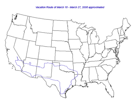
Approximate Route shown on US map above.
Links to external websites have been added below for information as to sites
we visited or passed through.
Links to photos has been added for each day and captions added to the larger
images (selected from the album page) that describe where the photo was taken.
Any questions or comments? Email me at timnew@timnew.com
Day 1 Thursday, March 16 Left Three Creeks, Arkansas at about 4 pm. Hwy 15 N to Hwy 82 bypass and east to Hwy 167. Hwy 7 N to Camden and then Hwy 79 east to Eagle Mills. From Eagle Mills Hwy 9 to Malvern and then Hwy 270 to Hwy 51 to Magnet Cove to drop off my Chinese Pug Grace. From Magnet Cove, Hwy 51 to Hwy 270 to Hot Springs and then on to Pencil Bluff, Ar where we took Hwy 88 to Mena, AR and stayed the night at the Limetree Inn. No Photos taken on Day 1. Traveled 216.4 miles.
Day 2 Friday, March 17 Left Mena, AR @ 8:16 am and traveled Hwy 88 west through Queen Wilhelmina State Park and then Hwy 1 through the Winding Stair Mountain NWR in OK ( AR Hwy 88 becomes OK Hwy 1). The original US boundary ended at the border here which was the Choctaw Nation. We followed Hwy 1 / 63 into McAlester, OK and then took the Indian Nation Turnpike NW to Henryetta, OK and then took I-40 West through Oklahoma City and across Oklahoma into the Texas Panhandle. We followed I-40 until we reached Vega, Texas and then we took Hwy 385 N to Dalhart, Texas where we stayed the Night at the Sands Motel. Breakfast at McDonalds in Mena, AR. Dinner (aka Supper) at Sands Restaurant, Dalhart, Texas. Traveled 601.7 miles.
Photos from Day 2: Dad's Album 1, Photos 1-8 from Tim's Album 1; Tim's digital photo 1
Day 3 Saturday, March 18 We took Hwy 87 NW to Texline and on into Clayton, New Mexico. There we took Hwy 56 / 412 to Springer, NM. I-25 N to Intersection of Hwy 58 to Cimmaron, NM and then Hwy 64 to Eagle Nest, NM. We then looped North on Hwy 38 to Questa, NM and then South on Hwy 522 to Taos, NM (pronounced so it rhymes with "house"). From Taos we followed Hwy 68 South to Pojoaque, NM and then Hwy 502 to Hwy 4 and Hwy 4 to Bandelier National Monument. Bandelier NM is a cliff dwelling. We doubled back to Pojoaque, Nm and then followed Hwy 68 to Sante Fe and then I-25 to Albuquerque, NM where we stayed the night at the Comfort Inn on Yale Ave in Southeastern Albuquerque. Breakfast at Sands Restaurant in Dalhart, Texas. Dinner at Lindy's Restaurant on Central Ave., Albuquerque, NM. Traveled 428.9 miles.
Photos from Day 3: Dad's Album 2, Photos 1-7 from Dad's Album 3; Photos 9-25 from Tim's album 1; Photos 2-24 from Tim's Album 2; and Photo 2 from Tim's Digital Photos. Petroglyph images from video.
Day 4, Sunday, March 19 Forecast was a winter storm moving into the region so we skipped church and headed west but first went south. We traveled this day in alternating sunshine, rain, sleet and snow. The rain was early and from Grants, NM west it was snow, sleet or sunshine. We left and took Hwy 47 south looking for the San Augustin Mission but we didn't see it. In Los Lunas, NM we took Hwy 6 to I-40 and I-40 west to Flagstaff, AZ. From Flagstaff we took Hwy 89A South to Wal-Mart and then doubled back to a previous exit for Hwy 89 North to Cameron, AZ where we stopped for the night at the Cameron Trading Post. We had a continental Breakfast at the Comfort Inn in Albuquerque and Dinner at Cameron's Trading Post. Traveled 414 miles.
Photos from Day 4: Photos 8-17 from Dad's Album 3, Photos 25 & 26 from Tim's Album 2; Photos 2-14 from Tim's Album 3, Photo 3 from Tim's Digital photos.
Day 5, Monday, March 20 Left Cameron Trading Post (a place I highly recommend) and took Hwy 64 west to the eastern entrance to Grand Canyon National Park. The first observation Point is Desrt View, followed by Lipan Point, A roadside Pull off, Moran Point, Grandview Point, a couple of road side view points and then Mather Point, Grand Canyon Visitor Center/General Store and then back to Yavapai Point and then the General Store again. The western view points were accessible by Grand Canyon Trolleys or Buses only and we decided to skip them and head on to Boulder City. From Grand Canyon we Hwy 64 south to Williams, AZ and I-40.We followed I-40 to Kingman, Az and then took Hwy 93 NW to Boulder City, NV driving over the Hoover Dam to get there. We spent the night with a cousin, Myrtis in Boulder City, NV . Breakfast at Cameron Trading Post and Dinner at The Railroad Pass Casino just outside Boulder City, NV. Traveled about 327 miles.
Photos from Day 5: Photos 18 - 24 from Dad's Album 3, Dad's Album 4, Photos 1-20 from Dad's Album 5; Photos 530-555 from Mom's digital photos 1; Photos 15-26 from Tim's album 3, Tim's album 4, Tim's album 5 , Photos 2-18 from Tim's album 6, and Photos 4-17 from Tim's Digital Photos.
Day 6, Tuesday, March 21 -- Left Myrtis' and ate breakfast at Mel's Diner, 558 Nevada Hwy in Boulder City. Left Boulder on Hwy 93 North to I-515 at Henderson, NV. Experienced car trouble just as we entered Henderson, NV (Speedometer went to 0, odometer quit working and the transmission would not shift to allow a speed greater than 50-55 mph). We exited I-515 about 4 miles up I-515 and returned to the Towbin Dodge Dealership. Spent most of the day at the Towbin Dodge dealership. Problem turned out to be a bad "wheel sensor" but mom decided to trafe while we waited and we left with a new Dodge Grand Caravan. We went ahead and looped Las Vegas on I-515 to the north and took Las Vegas Blvd aka "Sunset Strip" and Hwy 604 south through Las Vegas. We then took I-215 back east to Hwy 93 and then back south to where we started the morning, Boulder City, NV. Spent the night at the Nevada Inn in Boulder City. Dinner was McDonalds at the south end of Sunset Strip. Traveled only about 50 miles today and ended up in the town from whence we began the day.
Photos from Day 6: Photos 21-24 from Dad's Album 5, Photos 1-8 from Dad's Album 6; Photos 556 - 565 from Mom's Digital 1, Photos 566 - 576 from Mom's Digital 2, and Tim's Photos 19 & 20 (new car) from Tim's Album 6.
Day 7, Wednesday, March 22 Left the Nevada Inn and went to the "Coffee Cup", 512 Nevada Hwy in Boulder City for breakfast. Left Boulder City via Hwy 93 again for Henderson, NV. Took I-215 west, exited for Wal-Mart and ended up driving on side streets until we finally reached it. Then took I-215 again west to Las Vegas Blvd. exit which is also Hwy 604. Took Hwy 604 south to Hwy. Hwy 160. Then Hwy 160 west to Pahrump, NV. Just northwest ot Pahrump we turned left on the road going to Death Valley Junction, CA. There we took Hwy 190 into Death Valley National Park. We stopped at the kiosk at the Park entrance and then at Zabriskie Point. We followed Hwy 190 until we reached the intersection for Bad Water which I think is Hwy 178. We turned left and drove 17 miles to Bad Water, Death Valley. This is the lowest elevation in North America at about -286 feet. The ground was coated in a thick layer of salt. We retarced our route back to Hwy 190 and followed it west through Death Valley exiting the park and then to the Intersection of Hwy 136. We took Hwy 136 to Lone Pine and then Hwy 395 to Bishop, CA driving alongside the Sierra Nevada Mountains. At Bishop we learned the roads we hoped to travel west to Fresno were all closed due to Snow. So we backtracked down Hwy 395 south to Hwy 178 and then took Hwy 178 to Ridgecrest, Ca where we spent the night at the Rodeway Inn. Had dinner (what we call supper here in the south) at La Fiesta Restaurant in Ridgecrest. Traveled about 464.4 miles.
Photos from Day 7: Photos 9-24 from Dad's Album 6, Photos 1-6 from Dad's Album 7 ; Photos 577 - 583 from Mom's Digital 2, Photos 21-26 from Tim's Album 6, Tim's Album 7, Tim's Album 8, and Photos 2-6 from Tim's Album 9 and photos 18-21 from Tim's digital.
Day 8, Thursday, March 23 Continental Breakfast at the Rodeway Inn in Ridgecrest, CA. Left the Rodeway Inn and took Hwy 178 west to Weldon, CA. It is a very scenic section of road. At Weldon we took the road to Kernville following the north side of Lake Isabella. At Kernville our plans changed again as we learned the weekend snows had closed the roads to the Giant Sequoia Nat'l Monument (South) and also the roads into Sequoia National Park from Fresno. We couldn't see the Giant Sequoias as planned. We then decided to go South to Palm Springs area and visit Tim and Hilda Curry. We traveled Hwy 155 south from Kernville to Hwy 178 again completing a loop around Lake Isabella. We followed Hwy 178 to Bakersfield, CA where we intersected Hwy 58 at mp 116 and took Hwy 58 east past Mohave, CA to the intersection of Hwy 395 again at Four Corners, CA. We followed Hwy 395 south to Hwy 18 and Hwy 18 to Victorville, Apple Valley and on to Yucca Valley. There we turned south on Hwy 62 to I-10 just west of Palm Springs. We followed I-10 to Monterrey Ave where we exited to visit Tim and Hilda. Hilda gave us a quick tour of the area. We spent the night at their house in Thousand Palms. Dinner at Tim and Hilda's. Traveled 387.3 miles
Photos from Day 8: Photos 7-24 from Dad's Album 7; Photos 1-8 from Dad's Album 8; Photos 584 - 596 from Mom's Digital 2; Photos 7-26 from Tim's Album 9, and Photos 22 and 23 from Tim's Digital.
Day 9, Friday, March 24 Breakfast at Tim and Hilda's. Left Tim and Hilda's and followed I-10 to Hwy 86 at Coachella, CA (just east of Palm Springs). We followed Hwy 86 past the Salton Sea (area is also below sea level) to El Centro, CA. There we turned east on I-8 and followed it toward Yuma. Just before arriving in Yuma, AZ we exited to Los Algodones, Mexico which is a border community catering to tourists with Pharmacies, dentists and opticians in addition to crafts and restaurants. I was looking for an acquantaince who is an optician there but she was off as luck would have it. After visiting Los Algodones, we left and returned to I-8 which we followed through Yuma, Az to where it intersected Hwy 10 near Casa Grande, AZ. We followed I-10 to exit 236 at Marana, AZ where we exited to go to the Saguaro National Park. I got twisted around on directions I was given by a local but eventually we found the park and drove through it to South Tucson where we intersected I-19. We took I-19 north back to I-10 and then I-10 east to Benson, AZ where we spent the night at the Baymont Inn. We ate at the Country Cafe which is owned now by an Indonesian Mother and Daughter. I had an indonesian beef dish. Traveled 477.7 miles
Photos from Day 9: Photos 9-24 from Dad's Album 8, Photos 1-7 from Dad's Album 9; Photos 597 - 605 from Mom's digital Album 2, Photos 2-14 from Tim's Album 10.
Day 10, Saturday, March 25 Continental Breakfast (extended) at the Baymont Inn (Best Hotel breakfast with room on the trip). Left Benson and after some confusion due to a lack of roadsigns, took Hwy 80 South to Bisbee, Az. We stopped in old Bisbee for coffee and made a quick driving tour through part of the town, then took Hwy 92 to "new" Bisbee in an effort for mom to locate teh church they worked at several years ago and then followed Hwy 80 to Douglas, Az and then on NE to I-10 again at MP 5 in New Mexico. We followed I-10 to exit 140 where we exited to visit La Mesilla, NM and eat at La Posta Restaurant, a favorite of mine. We left La Mesilla and rejoined I-10 and followed it through El Paso, Texas and on to Fort Stockton. We had not planned to travel that far but did not see any place to stay after leaving Van Horn, Texas. We stayed at the Economy Inn at Fort Stockton, TX. Dinner was from our supplies. Traveled 588 miles
Photos from Day 10: Photos 8-24 from Dad's Album 9; Photos 607 and 608 from Mom's digital 2; Photos 15 - 25 from Tim's Album 10 and Photos 24 - 27 from Tim's digital.
Day 11, Sunday, March 26 Continental Breakfast at the Hotel in Fort Stockton. We left Fort Stockton on I-10 and followed it to San Antonio. We took West Durango to Santa Rosa and Santa Rosa to Houston and Houston to Alamo Plaza. We then circled to a parking deck on East Commerce. We toured the Alamo and part of the River Walk. We left San Antonio on Hwy 281 south to Hwy 97 west for a short time until it intersected Hwy 16 South. We followed Hwy 16 South to a few miles past Hebbronville, Tx where we took Hwy 649 to Hwy 83 east of Roma, Texas. We took Hwy 83 west to Roma and then crossed the border into Miguel Aléman, Mexico. We stayed the night at "El Tio Luz" hotel. I visited the "Templo Belem" arriving late for the services (at 7 pm and services started at 6 pm). Dinner was at the El Tio Luz Restaurant for mom and dad. I skipped to attend church. Traveled 549.1 miles
Photos from Day 11: Photos from Dad's Album 10 (not uploaded yet), Photo 26 from Tim's Album 10 and Photos Tim's Album 11 (not uploaded yet).
Day 12, Monday, March 27 Breakfast at El Tio Luz. We left Miguel Aléman early (about 7:30 am) and headed east on Hwy 83 to Harlingen and Hwy 77 North. We stopped at a fruit stand on Hwy 77 just outside Harlingen to buy Oranges and Grapefuit. We followed Hwy 77 North to the intersection of Hwy 59 near Victoria, Tx and then followed Hwy 59 north through Houston and on to Carthage, TX where we took Hwy 79 into Greenwood, LA. At Greenwood we turned onto I-20 and followed it to Minden, LA where we took Hwy 79 to Homer and from Homer Hwy 520 to Hwy 2, turned right and followed it a short distance to Colquitt and then turned left to followed the road to La Hwy 161 which becomes AR Hwy 15. We followed it the short distance back to Three Creeks. Stopped at McDonald's in Refugio, TX around lunch and stopped at Wendy's in Bossier City, LA for dinner. Traveled about 730 miles.
Photos from Day 12: Photos from Dad's Album 10 (not uploaded yet), and Photos Tim's Album 11 (not uploaded yet).
That completes the Photo Journal of our Trip west.